Explore in 2D or 3D.
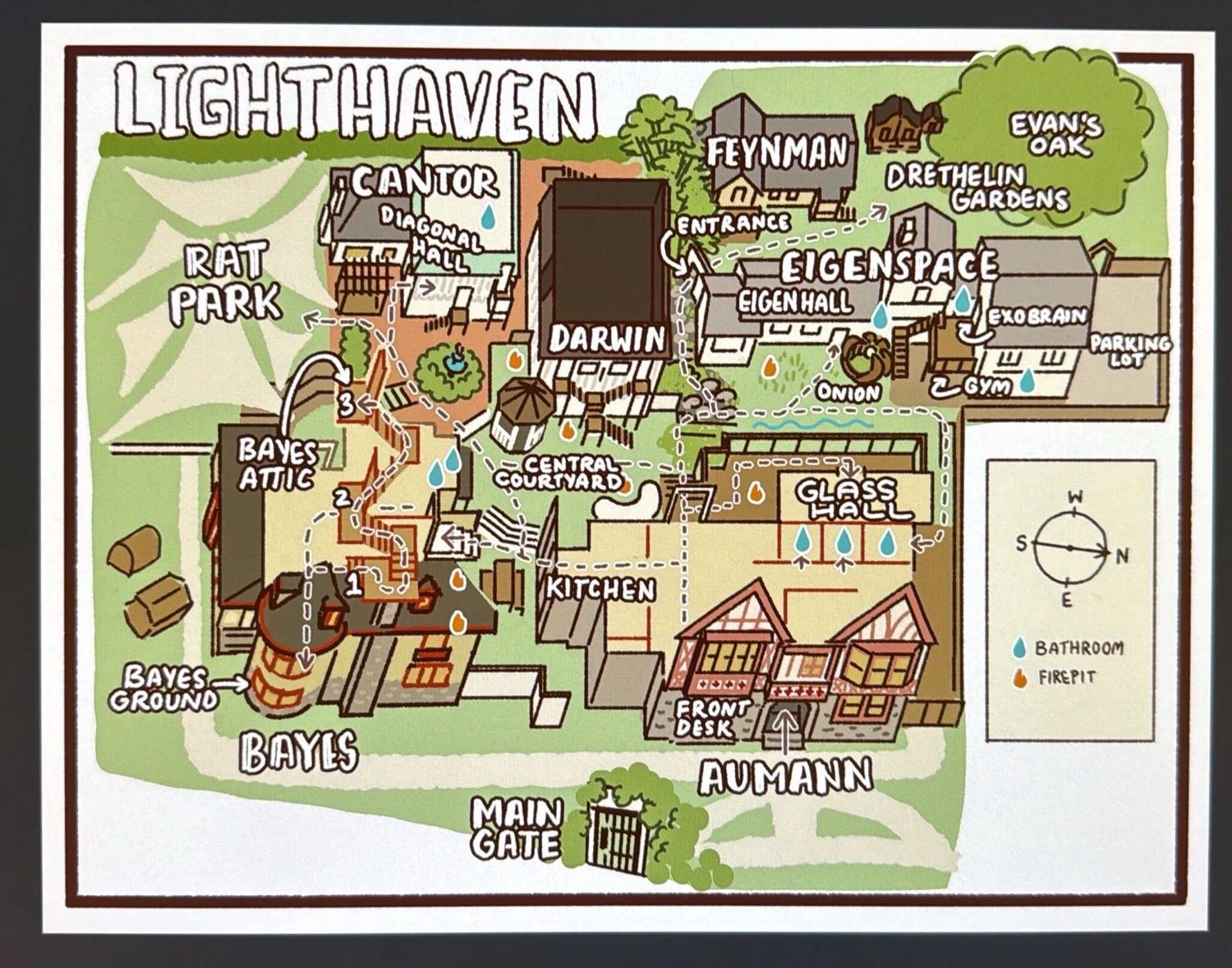
This is an independent, interactive guide made from Lighthaven reference maps. Start with a top-down map: drag to move and scroll or pinch to zoom. Switch to 3D to rotate and tilt the campus.
What’s grounded in the references: named buildings and spaces, their broad adjacency, the main gate, and the bathroom and firepit symbols.
What’s approximate: building footprints, heights, roofs, landscaping, room-pin positions and path connections.
The illustrated map is the primary layout reference. The aerial informs the architectural appearance; it has not been photogrammetrically aligned or calibrated. Indoor floor plans are not included. Room pins therefore locate named spaces within or beside buildings, not exact interior boundaries. Hiding roofs does not reveal a verified floor plan.
Glass Hall is Aumann’s open rear terrace, not a separate glass house. The deck dimensions and furnishings are schematic.
Bathroom and firepit pins are approximate transcriptions of symbols; their exact doors, floors and current availability are unverified. The compass follows the illustrated map: north is to its right.
Highlighted paths show approximate connections from the main gate and stop near the relevant building or outdoor space. They are not turn-by-turn, accessible-route or emergency instructions. Follow on-site signs and staff guidance.
A few ways to explore.
One finger / dragMove the map; rotate and tilt in 3DPinch / scrollZoom in and outTwo fingersPan and pinch togetherRight drag / ShiftPan with a mouseArrow keysMove the map in 2D; orbit in 3D+ / −Zoom in / out0Show the whole campus/Search for a spaceEscClose a panel or clear the selection
Tip: tap a label or building to focus it. Use the directory to find labels that are hidden to avoid overlap. “Extra room labels” prioritizes the smaller named spaces; labels may still be suppressed when they collide.
Local, lightweight, and private.
The 3D renderer and reference images are included in this page. There are no external scripts, fonts, map APIs, accounts, GPS requests or analytics. It can run offline in a WebGL-capable browser. Reduced-motion preferences are respected.
Place descriptions follow the reference maps. This is not an official Lighthaven map. Official Lighthaven website ↗